.jpg)
Royal Docklands Regeneration & Revitalisation
Acerca de

Green/Blue network
The Silo-D area
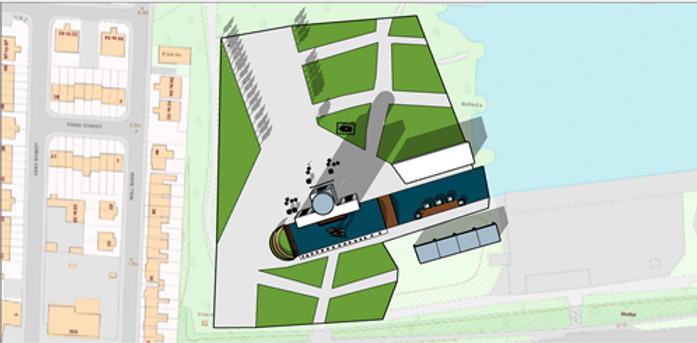
Overall Layout (Based on 1:10,000 map)
Site layout
Source: Myself - Sketchup
Map sourced from Digimaps
The Silo-D site has a great mixture of green and blue infrastructure. The most significant blue infrastructure is from its pontoon dock. This is a key area to the whole site for regeneration as it plays a key historical character to the whole site with its shipping history. Other features to be seen around the site include:
-
The Silo D park is northeast of the Silo-D building. This will involve community art projects and features as discussed previously that will consist of installations for visitors to interact with. This will cater for the community centre activities and for leisure.
-
The Westside open green space is primarily for the adjacent residential area which gives their front viewings a more picturesque and attractive viewpoint. from the used road This is to be used as an open space for any visitor. The shape of the open space contributes to the aim of direction towards the silo d from the millennium mills area, thus connecting these two heritage buildings together with its history.
-
The south park allows for more space for visitors to sit and stay near the water features south outside the Silo-D building. The green space will host multiple seating spaces for visitors.
-
The Dock is the main water feature that flows outside the silo-d area and this will be used as a play zone. South of this is a water display play zone to be used for kids.
Let’s Work Together
Get in touch so we can start working together.


Source: My image